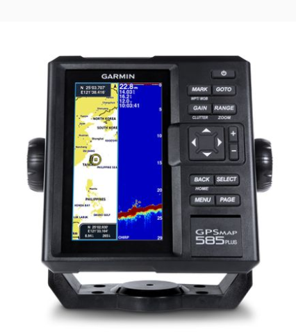
GARMIN GPSMAP 585 Plus 探鱼仪
制造商: GARMIN Model: GPSMAP 585 Plus - 联系
Physical dimensions: 176.0 mm x 190.0 mm x 66.0 mm (6.93” x 7.48” x 2.60”)
Display size, WxH: 2.83" x 5.36"; 6.0" diagonal (72.0 mm x 136.2 mm; 152.4 mm diagonal)
Display resolution, WxH: 480 x 800 pixels
Display type: WVGA display
Weight: 816.0 g (1.80 lbs)
Water rating: IPX7
GPS receiver: GPS/GLONASS/BeiDou, internal
NMEA 0183/RS422 compatible: V
Power consumption: 7.6 W
Voltage range: 10V - 36V DC input
Mounting options: Bail or flush
Maps & Memory
Preloaded maps: GPSMAP 585 Plus, APAC (worldwide basemap) GPSMAP 585 Plus, w/g2, SEA (built-in SEA g2 chart)
Accepts data cards: 2 standard SD
Waypoints: 12,000
Routes: 200
Track log: one 50,000 points active track; 100 saved tracks
Chartplotter Features
Garmin Sonar compatible: V
Supports AIS (tracks target ships position): V
Supports DSC (displays position data from DSC-capable VHF radio): V
Tide tables: V
Sonar Features & Specifications
Transmit power: 600W (RMS)
Sonar Frequency: 50/77/200kHz CHIRP (Low, Mid, High)
ClearVü™: (built-in)
Scanning Sonar Frequency: CHIRP 260/455/800kHz
Maximum depth: 2,300 ft, freshwater, 1,100 ft, saltwater (depth capacity is dependent on water bottom type and other water conditions)
Bottom lock (shows return from the bottom up): V
Water temperature log and graph: V
Split-screen zoom: V
Fish Symbol ID (helps identify fish targets): V
Sonar recording: V
Sonar history rewind: V
Connections
Transducer Connector Pin Numbers: 8
8-Pin Power/NMEA 0183 Connector: 1
BNC for External GPS Antenna: 1
- 质量承诺
- 正品保修
- 送货到家
- 交易简单化